3DFIN scan outputs
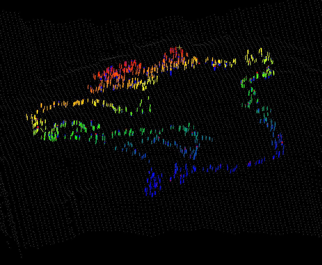
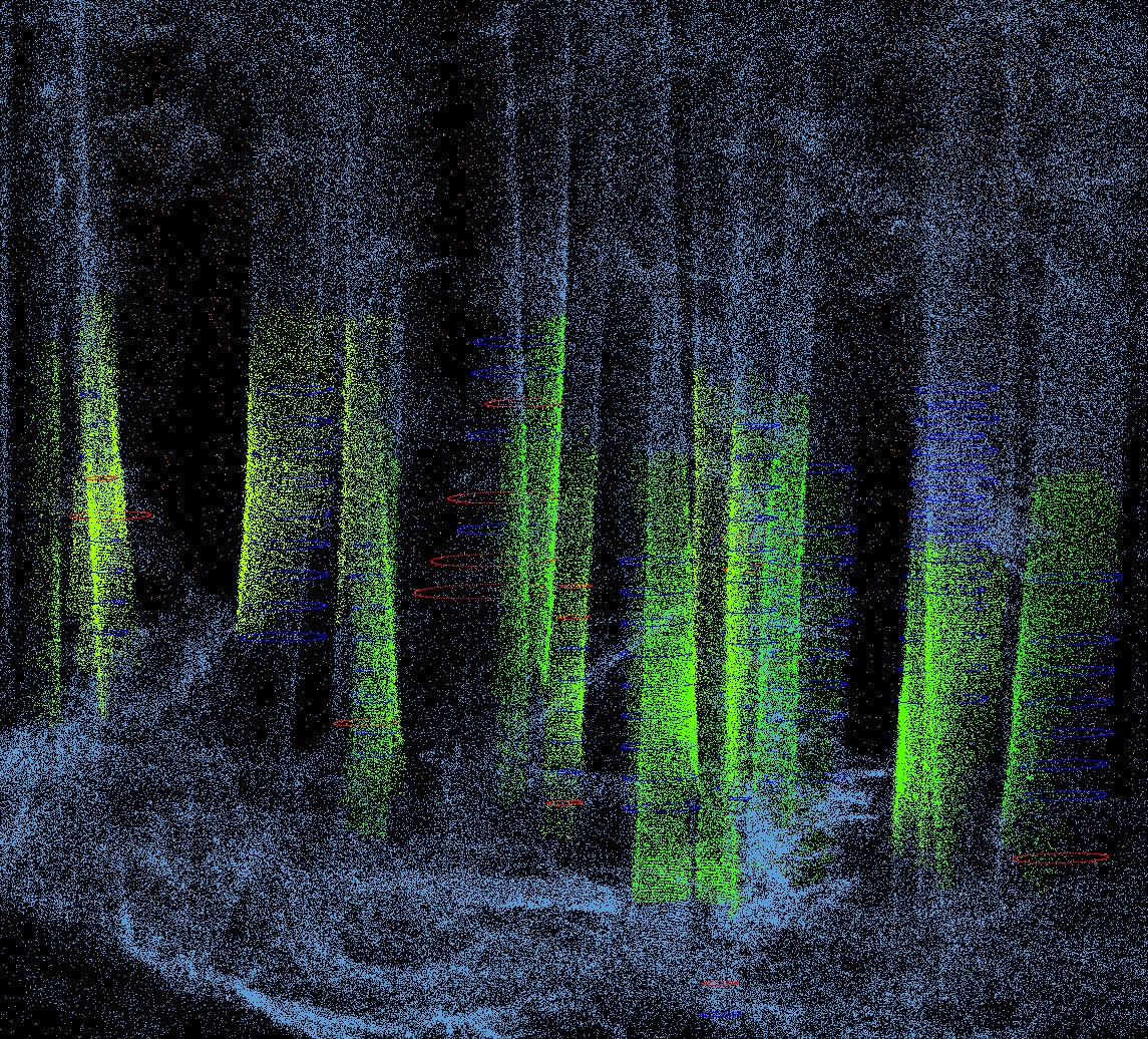
Block G043B4SG sits at the interior margin of Howe Sound's remaining old-growth corridor. The December 2023 BC Timber Sales hydrology review identifies G043B4SG as a 12.4-hectare planned block, or roughly 30.6 acres, inside TSL A94817. ELCS opposes cutting this block. The scan is part of the evidentiary record for keeping it standing.
The current Block G04 processing pass detected 680 trees in the scan. Diameters were calculable on 138 of those stems where the trunk geometry was sufficiently exposed for reliable section fitting. That distinction matters: the 680 count describes visible stems detected from the point cloud, while the 138 diameter values describe the subset that passed measurement-quality checks.
ELCS Position
ELCS is against harvesting Block G043B4SG. The block should be removed from the timber sale and protected as part of the remaining old-growth forest structure around Roberts Creek, Elphinstone, and the proposed park expansion area. Our concern is not limited to individual large trees. The stand contains a connected forest system: mature stems, small drainages, seepage zones, slope breaks, understory structure, and hydrologic pathways that are difficult to replace once cut.
This record is therefore not a neutral harvest note. It is a conservation record. We are using SLAM LiDAR, 3DFIN stem detection, field measurements, and the public hydrology review to show what would be lost if the block is logged, and to support the case for keeping the forest intact.
Hydrology Review Context
BC Timber Sales' Phase 3 Hydrology Review for TSL A94817 was prepared by Polar Geoscience Ltd. and dated December 8, 2023. It reviews planned blocks G043B4SG and G043C3ZP in the Roberts Creek and Stephens Creek watersheds, with a specific mandate to evaluate site-level hydrologic hazards and compare the harvest plan to prior Phase 1 and Phase 2 watershed recommendations.
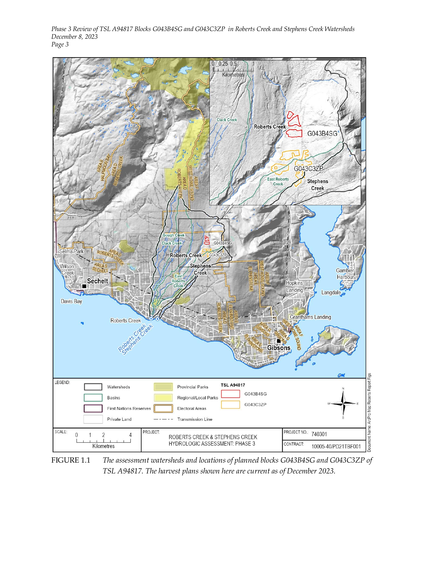
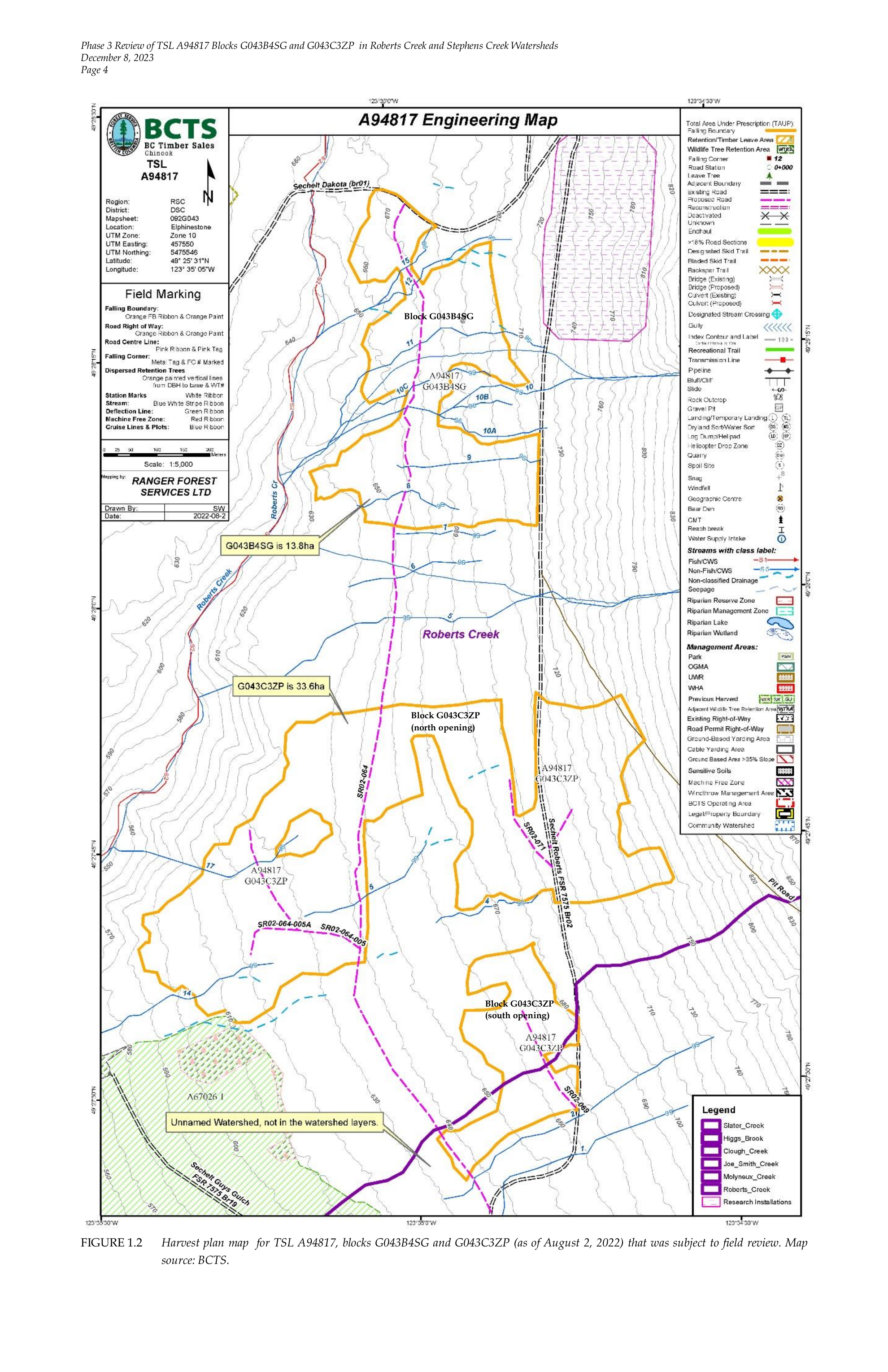
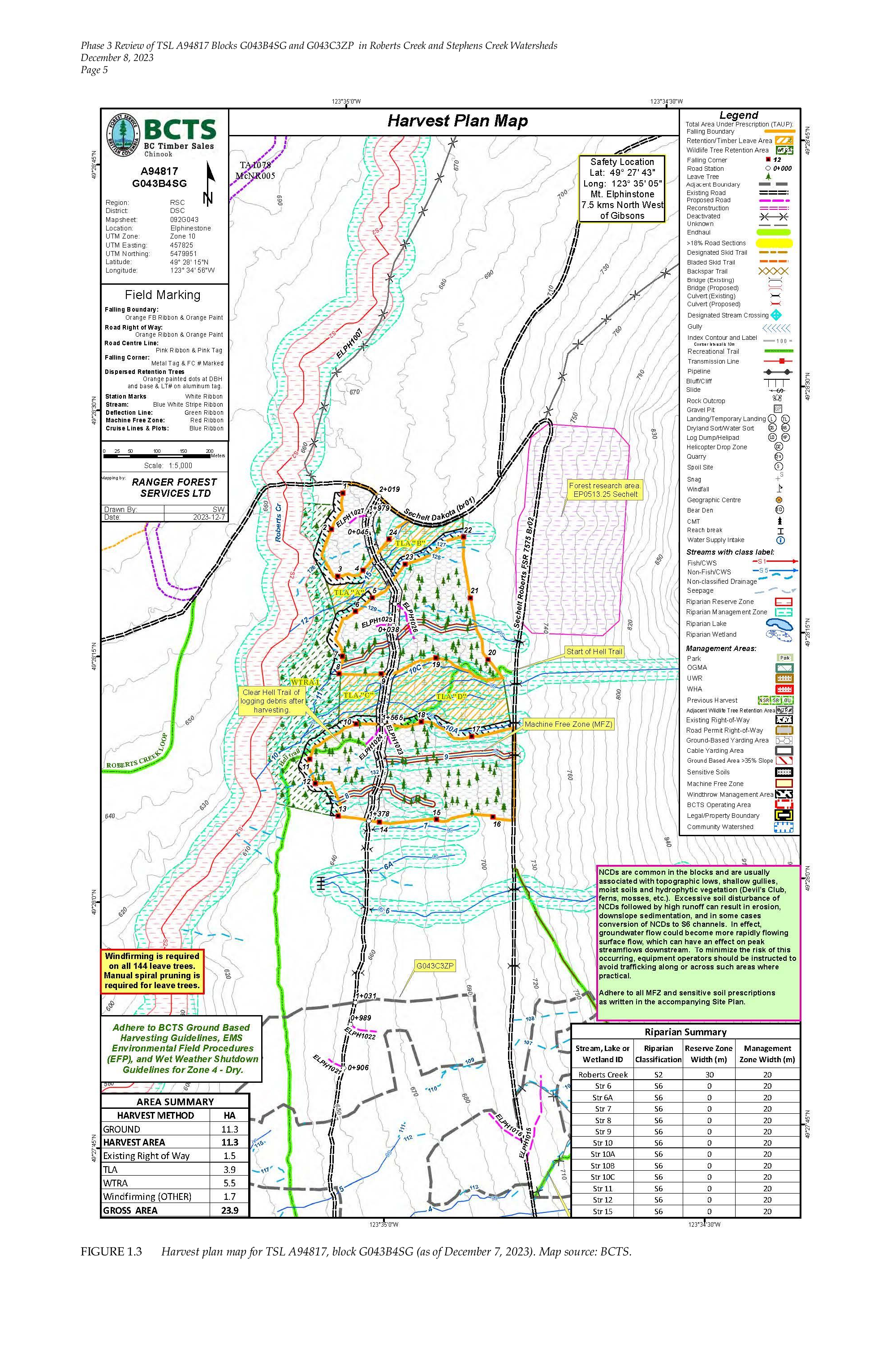
The key source maps for this atlas record are Figure 1.1, which locates the assessment watersheds and planned TSL A94817 blocks; Figure 1.2, which shows the August 2, 2022 plan reviewed in the field; and Figure 1.3, which shows the revised December 7, 2023 harvest plan for G043B4SG. We reproduce the relevant map pages below with source attribution and links to the original public government PDF.
Locates TSL A94817 blocks G043B4SG and G043C3ZP inside Roberts Creek and Stephens Creek watershed context.
MAP SOURCE · FIGURE 1.2 August 2022 field-review planShows the earlier G043B4SG/G043C3ZP plan used during the August 8, 2022 field review.
MAP SOURCE · FIGURE 1.3 December 2023 G043B4SG planShows the revised G043B4SG harvest plan, including the smaller three-opening layout.
What The Hydrology Review Says About G04
Polar's field observations place G043B4SG entirely within the Roberts Creek Watershed, on the eastern side of Roberts Creek near the upper end of an incised broad ravine. The report describes gentle hummocky terrain, dry soils during the August 2022 review, and some moist or wet ground likely associated with seasonal groundwater seepage.
The hydrology review also identifies G043B4SG as having higher drainage density than the other TSL A94817 blocks. Most of those features are S6 streams and non-classified drainages, but one stream, labelled 10A in the report, is called out as active: downcutting, laterally shifting, and near the upper width range for S6 streams. The report notes that parts of stream 10A had only a narrow buffer of about five metres in the August 2022 plan, creating potential windthrow and sediment risk to the stream, with likely sediment conveyance to Roberts Creek if windthrow occurred.
That is where the LiDAR record matters. A mobile scan can show the relationship between stems, small channels, wet ground, roads, slope breaks, and stream buffers at much finer resolution than a harvest-plan polygon. The point cloud does not replace hydrology field review. It gives reviewers a measurable structural layer for checking where the mapped drainages, NCDs, retained stems, and proposed road alignments sit in three-dimensional space. For ELCS, that evidence strengthens the case against logging the block.
| Hydrology item | Source detail pulled into this record |
|---|---|
| Watershed | G043B4SG is entirely within the Roberts Creek Watershed. |
| Drainage density | The report identifies higher drainage density in G043B4SG than in the other TSL A94817 blocks. |
| Stream 10A | Active S6 channel, downcutting and laterally shifting, with channel width near 3 m and locally exceeding it. |
| Buffer concern | August 2022 plan showed about a 5 m buffer along portions of stream 10A; Polar recommended at least 15 m or wider if a windthrow assessment required it. |
| December 2023 revision | G043B4SG was reduced from 13.8 ha to 12.4 ha, split into three openings from 1.62 ha to 6.11 ha. |
| Acreage note | This record uses the December 2023 Table 5.1 planned-block figure of 12.4 ha, or 30.6 acres. Figure 1.3 separately shows 11.3 ha harvest area and 23.9 ha gross area in its map area summary. |
| Low-flow protection | Openings were separated by at least two tree heights, with 144 leave trees marked in each block and subject to windfirming. |
Plan Revisions And What To Check
The December 2023 plan responds to several of the hydrology review's concerns. Polar reports that G043B4SG was reduced from 13.8 hectares to 12.4 hectares, with the revised plan split into three openings between 1.62 and 6.11 hectares. That puts each individual opening below the report's recommended eight-hectare net-opening threshold for conserving summer low flows.
For acreage, this article now uses 12.4 hectares as the current planned-block figure, which converts to 30.6 acres. The December 2023 map has a more detailed area summary: 11.3 hectares of harvest area, 1.5 hectares of existing right-of-way, 3.9 hectares of TLA, 5.5 hectares of WTRA, 1.7 hectares of windfirming treatment, and 23.9 hectares of gross mapped area. The older August 2022 plan labelled G043B4SG as 13.8 hectares, or roughly 34.1 acres.
The report also says BCTS revised the G043B4SG plan to remove substantial portions of the block from the riparian zones of streams 10, 12, and 15; establish minimum five-metre machine-free zones on each side of other S6 streams; avoid machine trafficking on non-classified drainages; and retain advanced regeneration or mature timber in machine-free zones where practicable. A terrain stability review also led to removal of a small area from the southwest corner of G043B4SG.
Those revisions are meaningful, but they do not make harvesting the block acceptable. They define what needs to be checked on the ground and in the scan: whether stream 10A has the space the report says it needs, whether NCDs and seepage zones are visible in the LiDAR-derived terrain and understory structure, whether road drainage preserves natural flow patterns, and whether retained trees are positioned to reduce windthrow and sediment risk rather than simply satisfy a map notation. The preferred outcome is protection, not a more carefully engineered cutblock.
The Scan
Our field team scanned the block in June 2026 using a SLAM mobile LiDAR unit. The system captures in motion — no tripod, no setup time per station — making it practical to collect dense forest structure on terrain that a tripod-mounted instrument could not access without rope work. Total acquisition time was 4 hours. The current processed dataset contains 30 million georeferenced points at sub-centimetre resolution.
The scan is designed to make the block legible in two ways at once. The LiDAR point cloud preserves the measurable structure: stems, slope, understory density, canopy openings, and the spatial relationship between large trees. The visualization layer makes that structure visible to people who are not reading raw forestry tables.
3DFIN Stem Analysis
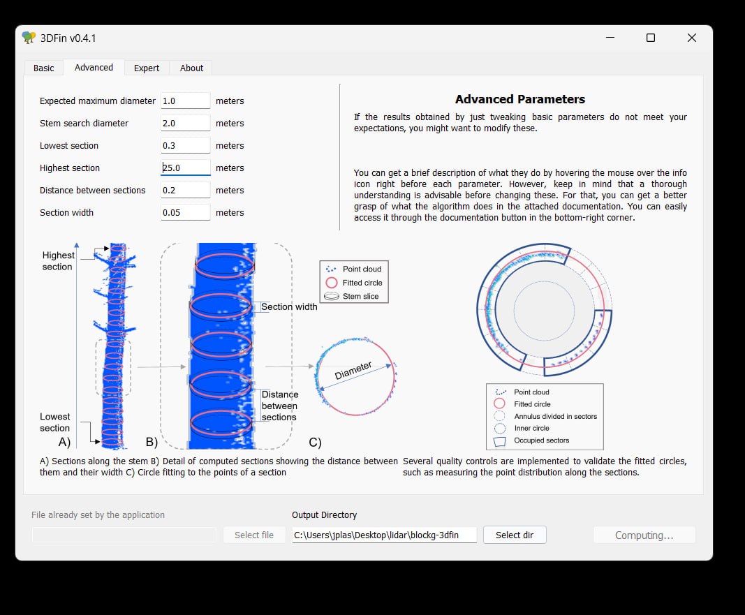
3DFIN was used to process the registered point cloud for individual stem detection and diameter fitting. In the current run, 3DFIN detected 680 trees across the scanned area. It then attempted diameter calculations by slicing detected stems into horizontal sections and fitting circles where point density and stem geometry were strong enough to support a measurement.
Diameters were calculable for 138 trees. The remaining detections are still useful as a stem-density and structure layer, but they are not treated as diameter measurements. In dense coastal forest, occlusion, lean, branches, buttressing, understory, and scan-path geometry can all reduce the number of stems that produce clean DBH fits.
DBH Calibration
The 3DFIN outputs are not treated as final inventory numbers on their own. ELCS uses manual DBH tape measurements and selected core samples to calibrate the LiDAR-derived measurements, especially on larger stems where buttressing, bark texture, and scan occlusion can bias an automated circle fit.
For Block G04, the immediate value is conservation triage: 680 detected trees provide a map of stand density and structure, while the 138 calculable diameters identify the stems that can already support numerical comparison. Field measurements can then focus on the biggest stems, ambiguous fits, and locations where 3DFIN detected structure but could not calculate a defensible diameter. The purpose is to improve the evidence for protection before irreversible harvest decisions are made.
Status
The block is currently active in a Section 12 referral under the BC Forest and Range Practices Act, triggered by a harvest application filed in February 2026. ELCS's position is that the block should not be cut. The scan data, 3DFIN stem analysis, and calibration dataset form part of ELCS's public conservation record for the site.
The forest is still standing. The scan is evidence that it exists, in exact detail, at this moment, and that it should remain standing.